The second problem I met was after the first stage of the process (I met per second because I realise it following the steps described in the other chapters): We should find a model to organise the world so it could be compatible with the game scenario.
United Nations and World Bank are using their own models (UN link, WB link)
Even if World Bank has a very good model, there are some decisions I really don’ like for example North Africa with Middle East, Indocine separated from South Asia, East Asia together with Pacific, Europe with central Asia … So I am afraid I had to identify my areas more on geographical criteria (than economic or cultural ones).
For the game I have organised the world in 8 areas, in alphabetical order: Africa, East Asia (with China), Europe (with Russia), Latin America, Middle East (with Arab peninsula), North America, Pacific, South Asia (with India).
NB. I am also evaluating 12 areas, adding Central america, China, Russia and India, but for this version 8 players
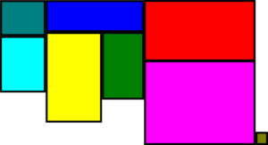
Here the map I am going to use: this has been generated considering population.

This map has been generated from real numbers, properly aggregated and charted using TreeView.
It is very interesting because with all data I am collecting, I can show different maps, and visually present how disegual is our planet.